Probability Map of Distributed Faulting in Italy
PDF-Italy 1.0 is a national-scale conditional probabilistic map of distributed faulting. This work builds upon and extends a previous DPC-funded initiative on DISS–ITHACA interoperability (published on: https://diss.ingv.it/ithdiss/), enhancing the joint use of the two datasets within a unified hazard framework. PDF-Italy includes two products: 1) a continuous map of distributed faulting likelihood across Italy, produced by aggregating conditional probabilities over a regular grid, and 2) an application to the ITHACA faults, providing probability estimates directly on the mapped structures.
Surface faulting induced by moderate-to-large earthquakes (Mw ≥5.5) may represent a significant hazard for infrastructures, as coseismic slip may propagate to the surface and activate both primary and secondary structures, producing distributed faulting, consisting of secondary ruptures and deformation affecting wide areas around the main fault.
The maps provided by PDF-Italy offer a quantitative representation of the spatial distribution of distributed faulting probabilities across Italy and on the mapped ITHACA faults. The probabilities shown are conditional probabilities, expressing the likelihood of distributed faulting associated with a moderate-to-large earthquake (Mw ≥ 5.5) occurring on a given source fault. They do not represent the probability that distributed faulting will occur within a specified time interval. Because distributed faulting can only occur if the causative earthquake takes place, the actual absolute probability of observing such phenomena at a given location and within a given period of time is substantially lower than the conditional probabilities displayed in the maps. Probabilities in Panel A of the figure are computed only for locations within 25 km of mapped seismogenic sources; areas farther away are assigned a probability of zero. The color scale in the maps is intended to highlight relative spatial variations in distributed faulting likelihood within earthquake scenarios and should not be interpreted as a measure of time-dependent hazard. Future developments will integrate fault slip rates and earthquake recurrence information to derive time-dependent probabilities.
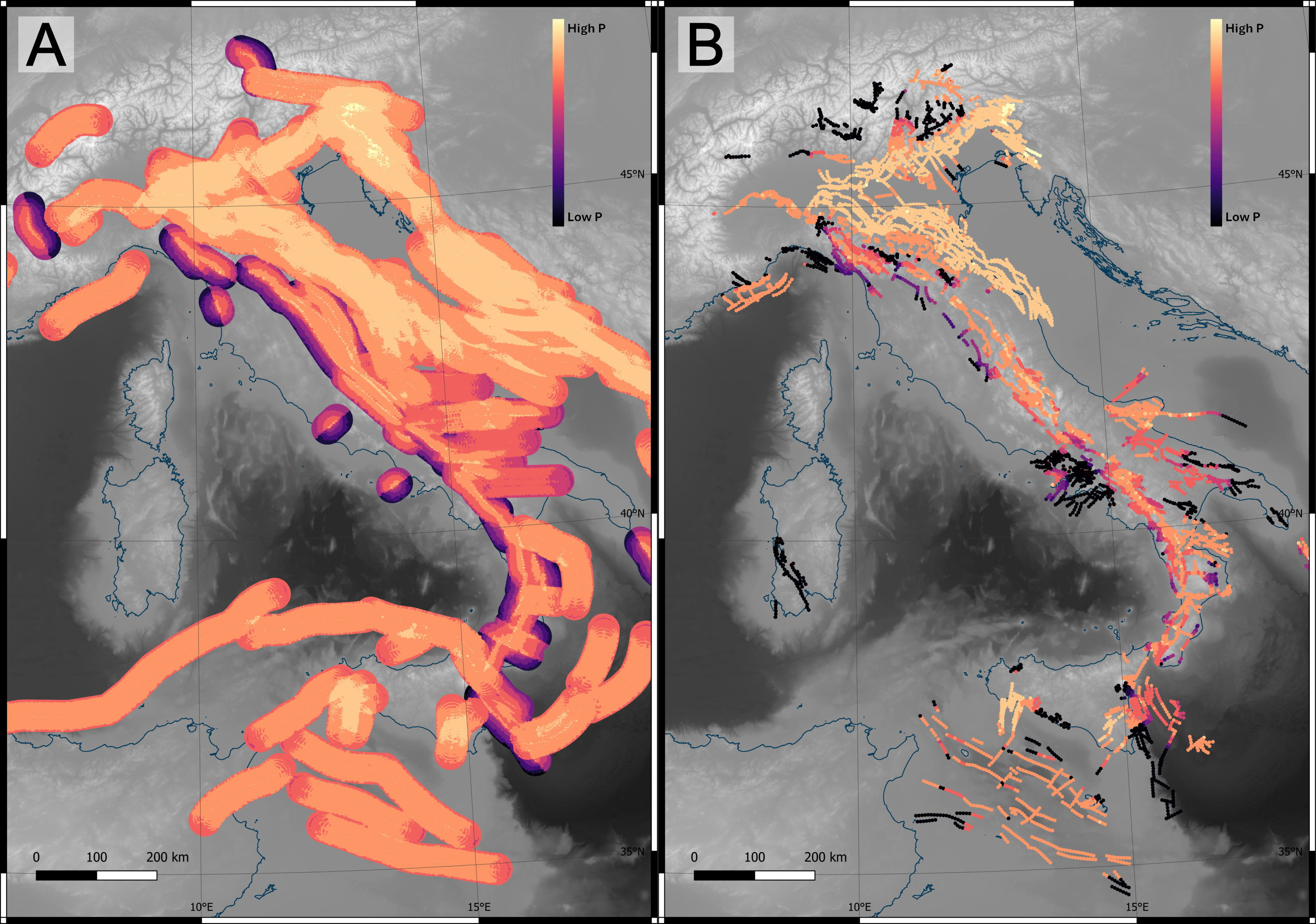
Figure. PDF-Italy products. (A) National-scale map of distributed faulting conditional probabilities associated with moderate-to-large earthquakes (Mw ≥ 5.5), calculated on a regular grid. (B) Conditional probabilities projected onto the mapped fault traces of the ITHACA database. Colors indicate relative variations in conditional probability within the modeled earthquake scenarios and should not be interpreted as time-dependent probabilities of occurrence.